
I am not sure what the generic is for a group of place names other than the rather scientific and nasty sounding onomasticon. In the case of Àird an Rùnair, a confusion seems appropriate.
We lack in most cases a historical record of the development of individual place names on Uist and so any thoughts tend to be supposition.
This headland is an important place and especially so in the days of sail as it is here that you reach a corner after which you no longer need to go west and can head south towards the rest of the West coast of Britain and Ireland or vice versa. This is also probably why, if you are a birder, it is the place to go in the UK to see Long-tailed Skuas.

The breif place name record I have is summed up in the table here. There are other instances of names but these are the important ones and includes all those I could find before 1790.
There is another name I will return to later which probably dates to Norse times.
There is another name I will return to later which probably dates to Norse times.
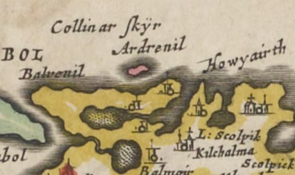
As can be seen the first name we have is on the Blaeu mapping of 1654, although based on Pont’s surveying of c 1600. The problem here is, as can be seen, it is unclear what the Ardrenil refers to. It could be the red island, it could be the headland or the settlement. The man who has kindly catalogued all the names on the Blaeu mapping, and so has had a fair amount of experience here, has it down as a settlement. I have to agree and think it is the name of the settlement out on the peninsula there, the name mirroring Balvenil (now Balranald) just to the south. These townships are supposed to be named after Ranald, leader of the Clan Gorrie who died in 1440.
This still leaves us with an anonymous but important headland. Martin Martin writing in 1703 about a stone nearby writes ‘There is a stone in the form of a Cross in the Row, opposite to St. Maries Church’. ‘Row’ is the usual way that ScG rubha = ‘headland’ is recorded in those days – Blaeu records several ‘Row’ headlands on his mapping e.g. Row Ardineen where I suspect that he has added a gratuitous 'Row' that has since been discarded.
Martin does not record a second name and it is possible that as an important landmark, the name he recorded could simply be that, technically called a simplex name. Alternatively, it could just be a general name he gives for the headland.
The next time it occurs as can be seen is on the Ainslie mapping where it is named Ardenruner, the first time we see an obvious precursor of the modern name.
There is further evidence that a ScG rubha name was there originally. On the OS 1st edition mapping of 1877 there are a Loch a’ Roe and Eilean na Roe place names on the peninsula. This suggests to me, but does not prove at all, that in fact, the headland did have a simplex name originally. Interestingly the cartographers continue to change things. On the current OS mapping, the loch is still named as the anachronistic Loch a’ Roe but the island is now updated to Eilean an Rubha. Not very consistent!
So where could Ardenruner have come from? Taking in the need for a ScG rubha component, I suspect that the ScG àird = ‘promontory’ was an addition created by Ainslie as he knew it was that feature but did not realise that the ScG rubha component gave him that topographical feature already.
This manipulation of place names by cartographers in this period is common enough. An example is Rubha Aird Druimnich on the North coast of the Ardnamurchan peninsula given to me by Anne Bankier. Previous forms included Ru Driminish (1851); Ardremonish (1820); Ardimnish (1806); Ardminish (1775); Ardremorish (1750); Ardremonish (c1750). As can be seen Àird and Rubha (and Nes)have been added or deleted over the years, probably at the whim of the cartographers, until today we get both just to make sure.
Going back to our name, Ainslie when creating the map, heard ‘anruner’ or the like and thought ‘It is a headland, I’d better put an Ard in front of it’ and created the name that we now have. Stripping back the Àird means the original name was Anruner or the more modern An Rùnair. The ScG an is a indefinite article.
I suggest that a starting for the remainder is ScG faire = ‘sentinel’. Remembering that an initial ScG 'fh’ does not sound at all then a possible route is ScG rubha an fhaire = ‘headland of the sentinel’. With the ‘bh’ and the ‘fh’ not sounded this would sound close to ‘ruanaire’.
Grammatically it is not quite as it should be as ScG faire is feminine and so the article should be ScG na without lenition i.e. ScG rubha na faire. However there is precedence here with four place names in Scotland of Beinn na h-Aire, ‘hill of the sentinel’, two on North Uist, one on South Uist and one on Harris.
Being a prominent landmark, the headland would be an obvious place for a watch point or a beacon fire and so the name makes good topographical sense, the litmus paper I consider important in testing possible roots.
There is perhaps some evidence that the name took time to become the norm as Reid on his mapping of 1799 records the headland as ‘Point of Hougary’, Hougary being the nearby township. The name has developed its own historical pedigree as ScG rùnair = ‘secretary’ however Beveridge sagely writes ‘although more probably to be associated with an earlier origin’ and confusion reigned with the nearby Loch Runabhat which is clealry Norse (or is is Rubha na bhàta?!)
Going further back in time, an interesting Norse word is ON hrannar which Vigusson defines as 'the heaps or swathes of seaweed and shells along the beach' describing exactly the beach at the end of the headland and inside it. Is this just a coincidence?! I wonder.....
And then there is one more twist. Beveridge refers to a name for the area around the church here, Colasaidh, and the Hebridean Connection gives the Gaelic equivalent Colbhansai both echoing the island name Colonsay and its Gaelic equivalent, Colbhasa. These place names however have no real date to help us.
Beveridge however spotted that Blaeu’s mapping however seems to provide what is now Causamul the name Collinar Skyr as can be seen on the extract above. The last component in clearly ON sker = ‘skerry’ but it is not impossible that some confusion has taken place and Blaeu gives his version of Colasaidh as Collinar and replacing what he percieved as an island suffix with a sjkerry one. I cannot quite see how the ‘s’ has disappeared, unless the desire to echo of Colonsay was strong enough to introduce the ‘s’ in the first place.
A recent document on the place name Colonsay writes ‘It is commonly believed to derive from Kolbeinnsøy, ‘Kolbeinn’s island’ (Kolbeinn is a personal name), it is more likely to derive from Norse Koll-vangsøy ‘island of Koll-vangr’ where Koll-vangr would be a place-name meaning ‘hill field’ and then Haswell-Smith gives us ON Columba's Isle. Here the -aidh ending would fit ON eið = ‘peninsula’ both pheonetically, for Beveridge’s version, and topographically. For me ON kolls eið = ‘peninsula of the rounded hill’ describes the headland well.
And then other local place names of Holf (Norse?) and Penmore (Gaelic? Norse? Pictish?!) could add to the confusion but that is for another day.....
 RSS Feed
