Timothy Pont is someone we do not know much about. However the legacy of his surveying work is huge. It took time but eventually, over fifty years after the survey work had been done, his maps were published by the Dutch Cartographer, Blaeu. It has been cl;aimed that at this time Scotland was then the best mapped countery in the world.
We are lucky that many of the original Pont manuscript maps survive, unlucky that for the Outer Hebrides, at present they only include a small section of South Uist,a manuscript map I talked about previously. Another thanks at this stage to the National Library of Scotland for their excellent section of digital maps.
The maps are not maps as we currently know them, but the more you look, the more you realise their worth. This post is looking at understanding one small section of Blaeu's map, the NW corner of North Uist.
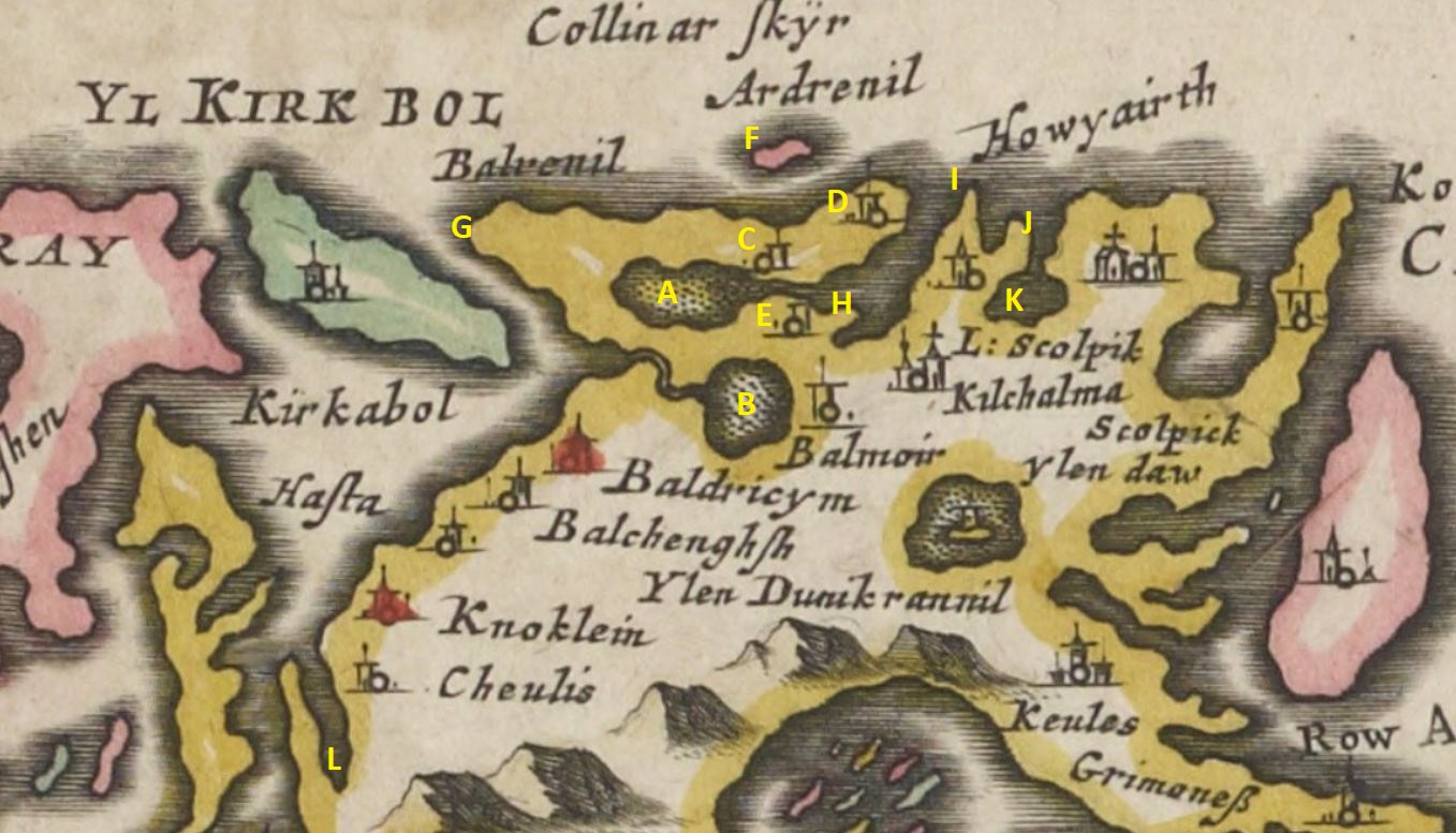
Elsewhere I have tried to identify the less obvious township names of Balchenghsh and Baldricym. I suspect the inlet marked L is the bay at what is now Bayhead working well in relative postion to Blaeu's Cheulis, modern day Caolas Pheibeil. One imagines Pont then surveying by traversing the ridge now called Druim Aird. In that case, the order of the townships is correct wiith the exception of Balmoir, a subject picked up later.
One of the key things to be aware of is that generally Blaeu represented fresh water lochs with a stippled area such as the loch marked A and B in the annotated verison of this area on Blaeu's map.
This does mean that B must be Loch Phaibeil with a stream running out to the sea there. In the later 1799 Reid map, it is said that the loch was recently drained and there is some detial of how the drain very quickly became overrun by the sea. It is possible with the period being one when sand blow was a real issue, this stream on the Blaeu mapping became blocked between the Pont survey of c1600 and the Reid mapping of 1799 hence the requirment for it to be drained.
The modern township of Balemore (ScG Baile Mòr) is adjacent to Craig Hasten and so presumalby has replaced Pont's Hasta. The Pont spelling of Balmoir indicates that perhaps the name meant the township of Mary as Moire is the Scottish Gaelic version of Mary, particularly the Virgin Mary. This fits well with the church nearby being called Kilmuir (Mary's Chapel). An additional small clue is the name Gearraidh Mor, SE of Balranald House on the OS mapping, in the same area as Pont's Balmoir. One wonders if originally it was Gearraidh Moire.
This does mean that the freshwater loch marked as A must the waterway including Loch Sgaraigh which Reid records in 1799 as draining to the sea just west of the Kilmuir cemetery.
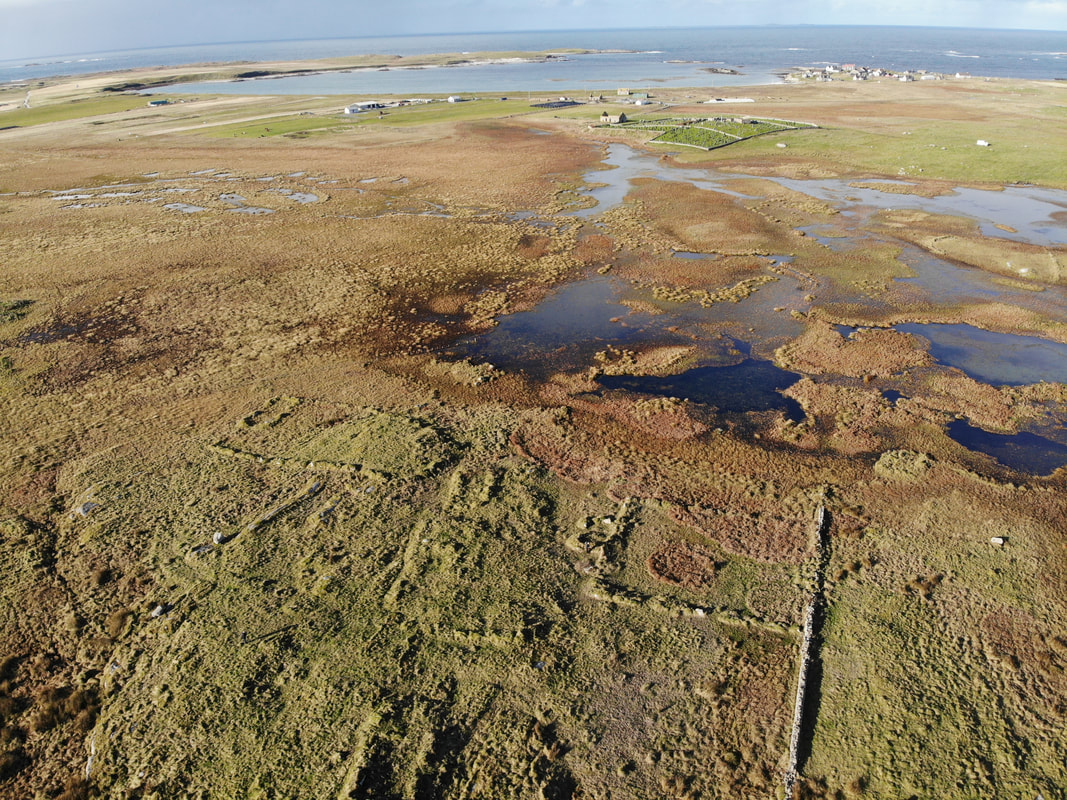
With a township recorded either side of that water course, E must be Hougharry and C Penmore, a township recorded on Reid but since deserted. The image above shows the cemetery at Kilmuir and where the waterway described above. In the foreground is what remains of Penmore and modern Hougharry is in the background.
It is possible that this township was originally called Penmoire, meaning the Virgin Mary's pennyland. Penmore would mean the large pennyland which would be odd as it is one of the smallest pennyland around as noted by Blackadder in his review of the North Uist estate in the early 1800s.
Balrenil is marked as G on the Blaeu map and must refer to Balranald although no township is marked. The exact locatiion of this township in interesting as on the Reid map it is in the proximity of Balranald House however the OS 1st series marks Balranald as an area on the machair to the west of the various water courses and indeed the hill there is named Beinn a'Bhaile which if Gaelic would tranlsate to Hill of the Township. This postion would fit neatly with Blaeu's mapping.
Collinar Skyr on Blaeu must refer to F as skyr comes from ON sker = reef, rock or skerry. This must be modern day Causamul being the only reef in the right area, although quite how that phonological transformation has taken place is a mystery. The name is itself Norse, presumalby from ON kasar + muli = reef of the heap. ON kasar is the genitive of ON kös which Vigfusson defines as "a heap, pile, as of stones, blubber, or the like". The blubber is interesting as Causamul is recored in 1703 by Martin Martin as "still famous for the fishing of seals there".
I suspect that Ardrenil then refers to the township D, as a township was know to exist there but no known name for it exists. We know the bard John MacCodrum was born in c1693 at Cladh Chomhghain, the burial ground on that headland. The root must be ScG aird = headland. As for renil then it might look obvious as Ranald but things are perhaps never that simple. Somethnig I might come back to.
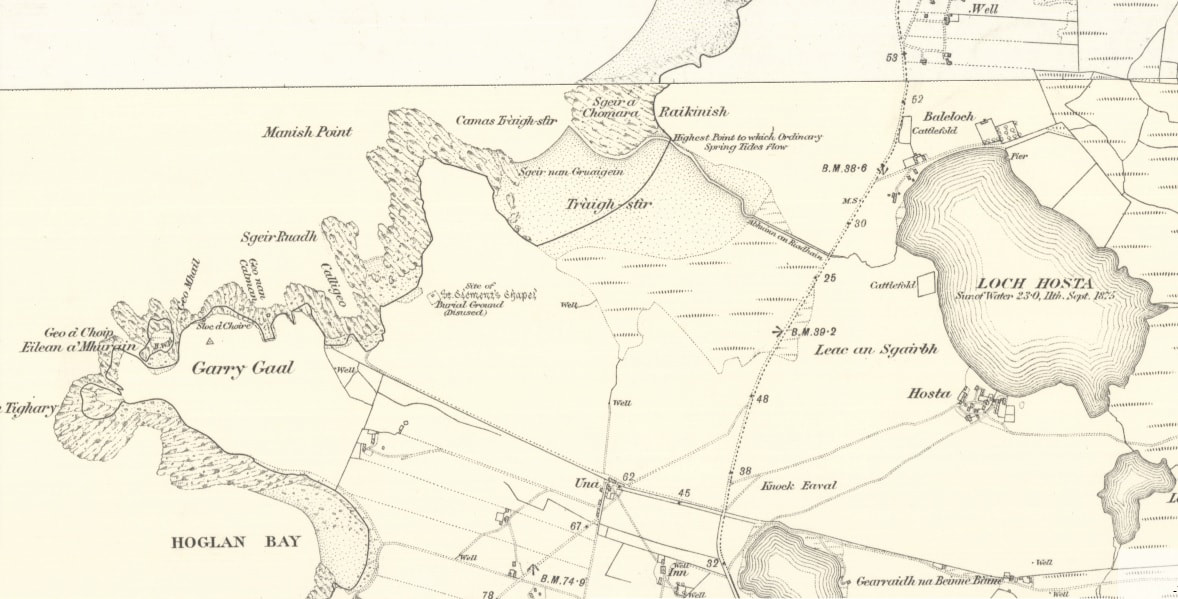
Topographically Blaeu's map is good on detail on the coast here with H being the promontory on which modern Tighgarry is placed, I would be Gearraidh Gall and J Rubha Mhanais. The label Howyairth must however refer to Hougharry and has been misplaced, perhaps transposed with Blaeu's Kilchalma, modern day St. Clement's Chapel. The 1st Series OS map for this area is shown above.
K must be Loch Hosta (the Loch Scolpik label being confusing but in fact referring to the sea loch to the right matching up with the township labelled Scolpick) but is interestingly unstippled and so Pont thought it to be saline. It is quite possible with this being a period of extensive sand blow that Loch Hosta was a sea loch at the time of Pont's survey but later the entrance got blocked by sand, a similar situation as hypotheisised for Loch Phaibeil. Unlike Loch Phaibeil this has not since been drained.
The level of the water was recorded as 23' above sea level on the 1st series OS in the 1860s. This might explain one of the legends in the area about one sept flooding Hosta township by releasing the water from a loch above the township.
As ever these oral traditons must be taken seriously and generally hold grains of truth. The truth here might be that Hosta township was origanlly a township on the seashore and did get flooded but it was as a consequence of the loch flooding as its exit to the sea was blocked by seven metres of sand.
 RSS Feed
