Wikipedia gives Dùn Vùlan as coming form ScG Dùn Mhùlan or Mhaoilinn meaning ‘fort of the hillock’ or ‘bleak eminence’ respectively.. Carmichael in the OSNB adds his pennyworth with a rather offbeat Dù Mhavilean meaning ‘McMillan’s Fort’..
I think the key is the fact that headland here is called Rubha Àird a’ Mhuile, a name that must share a root with Dùn Vùlan. As is often the case the OS 1st edition mapping names are much easier to use when discussing possible early roots. Here then we will discuss Rudha Ardvule and Dùn Vulan. If the names are linked then both the Gaelic interpetations above would not work as they would not provide the ‘vule’ of the headland. Carmichael spotted this link by providing Rudh Aird Mhavile as his option and interpreting this as McMillans Headland’ Again however I fear he is off the mark.
I have seen ‘mill’ cited as a possible root from either ScG muileann or ON mylla. The latter seems unlikely as it lacks the /n/. The first might work for the dùn name but does not seem good for the rubha name. Topographically too this does not seem a good site for a mill without any decent flowing stream.
A difficulty is trying to work out whether the /v/ sound comes from the lenition process so was originally /m/ transforming to /mn/ with the effect of lenition and so sounding live /v/ or whether no lenition has taken place and the initial letter was /v/. Either take us to two possible Norse roots. ON völlur means ‘field’ and occurs as a simplex place name 25 times in Iceland. Vøllen occurs four times in Norway and Vollen more than a hundred times there. This would be a good pheonetic match for /vula/ and in the acc definite case ON völlinn = ‘The field’ would be a good fit for Vulan.
With the nearby Bornais (ON borg nes = ‘headland of the fort’) Norse settlement, excavated by Niall Sharples, about one kilometre to the west, these could well be the fields associated with that settlement. However of all the land near to those Norse buildings this is possibly that which is least likely to be called a field.
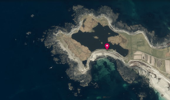
ON möl =’shingle’ and often comes to mean a storm beach, a relatively steep beach made up of large pebbles and rocks. The nominative definite form is ON mölin = ‘The storm beach’. Möl occurs as a place name in Iceland five times with Mölin once whilst in Norway Molen occurs eight times. Topographically this is a much better fit as can be seen in the satellite imagery of the site. Dùn Vùlan is marked with the red flag. The storm beach is clear to the S of it. With an /h/ inserted in the process of creating a Gaelic name, the sound is a good match.
| Interestingly (at least I think so) Pont records a ‘L: Veulin’ further south on South Uist. This loch is positioned adjacent to Kilvrid (Kilbride), Lochen Chory (Loch a’ Choire) and Loch bes huffad (? Loch Aiseabhat – a different story but it seems not impossible to confuse B and æ in secretary hand, the script of the day). | 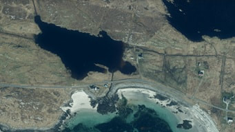 |
 What is now Loch a’ Bhruga on the S shore of South Uist would be a good match. It is not well sited to be a field name but there is a storm beach there. The image shows this | 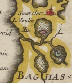 |
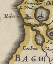
| The Pont map shows an island with a fort on it however when this area is copied on another section of the map covering Barra, on that map the fort has disappeared. There is no obvious for an island suitable for a fort on the current loch. The map on the right here is the ‘copy’. I would expect the one on the left to be the more accurate. | 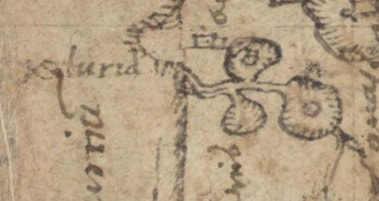 |
Looking at the satellite imagery, it is possible to imagine the area to the right of the loch being an island on which there could have been a fort. This is the one area where Pont’s original surveying map survives and the relevant extract is here. It is not 100% but comparing the two islands here, on the one to the left I think he meant to show a building.
The name Loch a’ Bhruga could well have ON borg = ‘fort’ as its root. The /h/ is added on account of the Gaelic lenition.
Taking all these bits of evidence, I suggest there was a fort on the ‘island’ in Loch a’ Bhruga and the root for both Rubha Àird a’ Mhuile and Dùn Vùlan was ON möl = ‘storm beach’
So by investigating the place name of one fort, we find the probable site of another!
Indeed it could even be the Brog of the eralier maps but that is another story.
With thanks to National Library of Scotland for the extracts of the Blaeu and Pont maps and to Googel Earth for the satellite imagery
 RSS Feed
