
Old Norse whale place names - Berneray
My previous post talked about drive hunting of whales. This one focuses on the possibility of the Norse practicing this in the Hebrides.
To be precise all these names are ScG but are included here as they possibly include ON whale roots hidden in their gaelicization. The names as on the OS 1st series are used throughout as the more modern names have been regaelicized confusing still further an already complex situation.
ON hvalr = whale is the generic word for whale. With the way ScG works on languages, this is likely to sound like veil.
Loch Veiligary on Berneray, Achaveilan Burn in Reay running into Sandside Bay (Caithness) and Veilish Point on Udal are the only three place in Great Britain containing the component veil in the OS GB1900 data. All three are near a topographical feature that might be used to drive whales.
The first, Loch Veiligary, is at the head of Bays Loch on Berneray in the Sound of Harris. The name could come from ScG Loch + ON hvalr + garðr = loch of the boundary of the whale. The ScG loch has just been appended to a place known as ON hvalr + garðr.
Lindquist hypothezied that coastal inhabitants in Norway, from prehistoric to modern times, caught pods of small and middle-sized toothed as well as (solitary) larger baleen whales in inlets with a favourable topography which they improved upon and prepared for the enclosure and trapping of cetaceans through special precautions, arrangements/constructions (of wood, wattle work and stone), called ON hval + garðr = whale garth, that such a site was a special legal entity, in early to high medieval times called ON hval + vägr = whale voe, as distinct from the ON hval + vik = whale creek which is merely a creek.
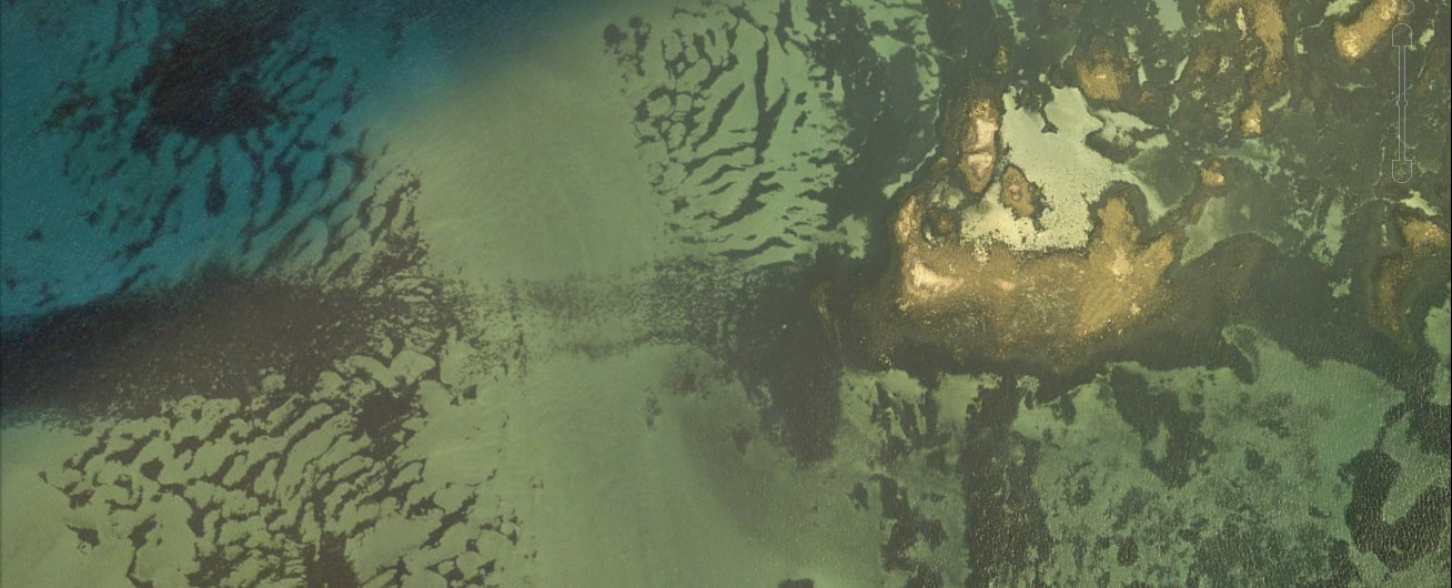
The google map extract shows the area concerned. Loch Veilgarry (A) is sited just above the foreshore of Bays Loch (D). As can be clearly seen there is a line running NW/SE (B) that would restrict movement of the whales out into the Sound of Harris. It runs for four kilometres with the NW two kilometres in particular being very shallow, drying at low tide. With boats to the W side, driving the whales onto the N shore of Bays Loch would be relatively straightforward.
The next most telling place-name is recorded in Mackillop’s The Place-Names of Berneray and lies at the point where the NW/SE line meets the shore – Feadan a’choin Chilleadh (C). Mackillop himself says this is a very difficult name to interpret and gives a relatively convoluted ScG ON hybrid name, Meadow of the church shrine.
A more straightforward possibility, using a relatively common ON hv to ScG ch transition, is ScG feadan + a’ + ceann + ON hvalr + eið. = the gap through which the wind whistles/howls at the head of the whale isthmus. The Gaels did not understand but knew a name for. the component ON hvalr + eið = whale isthmus which describes the NW/SE line perfectly and indeed presumably gives us the name for it that preceded the current bland ScG riof = reef.
The totally (un-naturally!?) straight nature of Chilleadh and close inspection of detail reveals some aspects of a man-made structure, possibly extending a natural feature. Two details are included here.
The first is at the SE end where even though areas have been cleared to some depth, there is still a clear straight line two-sided structure on the sea-bed.
My previous post talked about drive hunting of whales. This one focuses on the possibility of the Norse practicing this in the Hebrides.
To be precise all these names are ScG but are included here as they possibly include ON whale roots hidden in their gaelicization. The names as on the OS 1st series are used throughout as the more modern names have been regaelicized confusing still further an already complex situation.
ON hvalr = whale is the generic word for whale. With the way ScG works on languages, this is likely to sound like veil.
Loch Veiligary on Berneray, Achaveilan Burn in Reay running into Sandside Bay (Caithness) and Veilish Point on Udal are the only three place in Great Britain containing the component veil in the OS GB1900 data. All three are near a topographical feature that might be used to drive whales.
The first, Loch Veiligary, is at the head of Bays Loch on Berneray in the Sound of Harris. The name could come from ScG Loch + ON hvalr + garðr = loch of the boundary of the whale. The ScG loch has just been appended to a place known as ON hvalr + garðr.
Lindquist hypothezied that coastal inhabitants in Norway, from prehistoric to modern times, caught pods of small and middle-sized toothed as well as (solitary) larger baleen whales in inlets with a favourable topography which they improved upon and prepared for the enclosure and trapping of cetaceans through special precautions, arrangements/constructions (of wood, wattle work and stone), called ON hval + garðr = whale garth, that such a site was a special legal entity, in early to high medieval times called ON hval + vägr = whale voe, as distinct from the ON hval + vik = whale creek which is merely a creek.
The google map extract shows the area concerned. Loch Veilgarry (A) is sited just above the foreshore of Bays Loch (D). As can be clearly seen there is a line running NW/SE (B) that would restrict movement of the whales out into the Sound of Harris. It runs for four kilometres with the NW two kilometres in particular being very shallow, drying at low tide. With boats to the W side, driving the whales onto the N shore of Bays Loch would be relatively straightforward.
The next most telling place-name is recorded in Mackillop’s The Place-Names of Berneray and lies at the point where the NW/SE line meets the shore – Feadan a’choin Chilleadh (C). Mackillop himself says this is a very difficult name to interpret and gives a relatively convoluted ScG ON hybrid name, Meadow of the church shrine.
A more straightforward possibility, using a relatively common ON hv to ScG ch transition, is ScG feadan + a’ + ceann + ON hvalr + eið. = the gap through which the wind whistles/howls at the head of the whale isthmus. The Gaels did not understand but knew a name for. the component ON hvalr + eið = whale isthmus which describes the NW/SE line perfectly and indeed presumably gives us the name for it that preceded the current bland ScG riof = reef.
The totally (un-naturally!?) straight nature of Chilleadh and close inspection of detail reveals some aspects of a man-made structure, possibly extending a natural feature. Two details are included here.
The first is at the SE end where even though areas have been cleared to some depth, there is still a clear straight line two-sided structure on the sea-bed.
The second is the central section where a straight line running behind the shore looks like a construction from which the shore has accreted over the course of time.
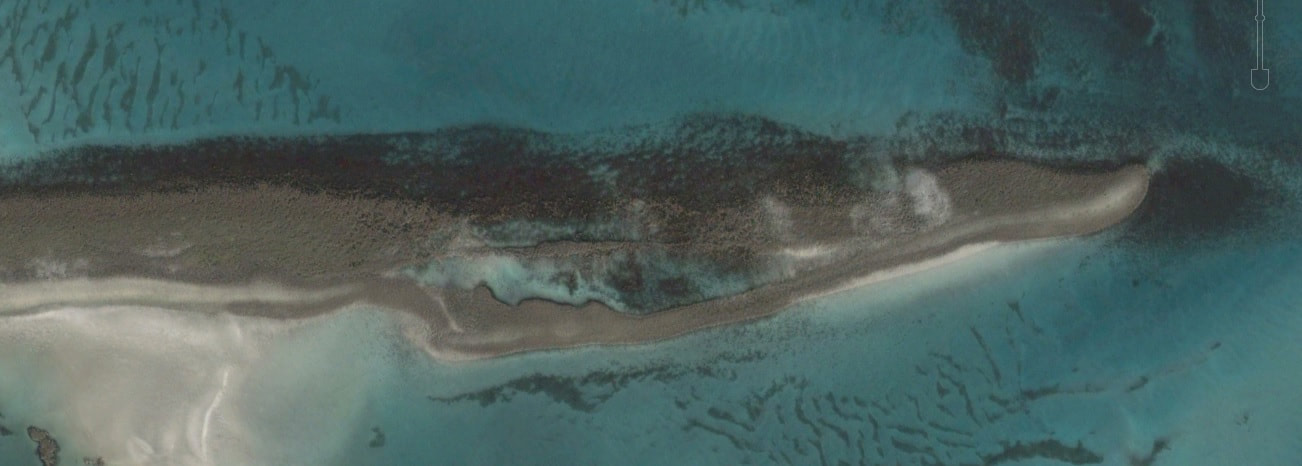
One or two sections have been dredged away. The more southerly one is used by the current car ferry service, the upper by small fishing boats at the right tide. The total length is almost exactly four kilometres.
Bays Loch (D) is an odd name as few names on Uist have an English component and certainly not one that introduces an obvious tautology, as is the modern Loch a’ Bhaigh.
There is a possible interpretation that fits with the idea of this being a place for driving whales. ON vagn = a type of whale, possible orca or some smaller species, and the genitive is ON vagns whilst ON lögr = the sea, large estuary or lake. ON vagns + lögr = sea of the whales would sound similar to Bays Loch and would be a fitting name if t his was the end of a driven whale run.
The small reef just off the long line NW/SE is called Vaitam (E). An obvious root would be ON vátr + holmr = wet islet but another possibility is ON veiðr + holmr = islet of the catch, hunting or fishing. Bizarrely, at least to my ears, ON holmr = islet usually end up as ScG -am or ScG -um in Gaelic.
The island at the end of the line is called Sgeir a’ Chail (F). As mentioned above ScG ch often stems from ON hv so ScG Chail becomes ON hvail, with ON hvalr = whale. Sgeir a’ Chail then has as its root ON hvalr + sker = skerry of the whale. The order is reversed as ON sker became ScG sgeir, an ON loan word used by the Gaels. The Gaels then knew ON hvalr + sker as a place-name, understood the skerry component and placed it first following their word order, the a’ indicating that they knew that place was called Chail did not know its meaning and are referring to it as the skerry of Chail. The OS Name Book quotes “Cabbage (Kale) rocks” which works pheonetically but not otherwise as cabbage would not enjoying growing on this skerry! There is however a story about an Irish ship with a load of cabbages foundering on the reef but this could be a folk etymology.
The next skerry SE beyond the end of Chilleadh is called Sgeir Sine which could come from ON sjónar + sker = a look out skerry, the same comment about the order as above applying here too.
Two other names that are perhaps overly speculative. There are two skerries called Sgeir a’ Chruinn and Sgeir a’ Chruinn Dhuibh (G) in the driven area. The Faroese word for Pilot Whale, and indeed the name for their hunt, is F grind. With ON nd transitioning to ScG nn then ScG chruinn is not far pheonetically from F grind.
One final name is Manish (H). This is the name for the promontory at the W side of Bays Loch. There are five area in the whole of Scotland with this name. One is on Ensay only 8km to the NE of Berneray. One is near Hosta on the NW coast of North Uist, one is on the W coast of Harris and the last is on Raasay, Skye. All are headlands and so the generic component must be ON nes = headland as one would anticipate.
As well as ON hval + garðr = whale boundary involved in driving whales there was also an ON mann + garðr = man boundary which was the men doing the driving forming a boundary. It could be interpreted as manned boundary and so Manish would be manned headland, forming part of the driving process.
There in one last possible pointer in an English place-name. The Admiralty chart of 1859 marks a channel through from the Minch to Bays Loch that very much follows the route the whales would have to follow on the drive. The name is the Grey Horse Channel. The idea of referring to a whale as a grey horse is not an unfeasible one!
Other Old Norse whaling place-names
Both the Raasay and the Harris Manish sites from above topographically look appropriate for driving whales.
The Raasay site is towards the top of the Outer Sound of Raasay but would be an appropriate place to start driving large whales south into the Narrows of Raasay. The beach on the W side of the Narrows is called Camas a’ Mhor - bheoil. With the ScG bh pronounced as a v this becomes beach of the large whale. As recently as 2013, there was a group of five Sperm Whales in the Inner Sound of Raasay.
Two other bheoil names occur in the same area as the Mull muca-mara name from the previous post.
The Harris site is much more similar to the Oban nam Muca-mara site in the previous post, with three possible creeks with narrow inlets to drive into, Ob Leasaid, Ob Scalla and the N end of Loch Flodabay.
Finally the second Hebridean place containing veil is Veilish Point on the W coast of the Udal peninsula. The root could be ON hvalr + nes = headland of the whale or ON hvalr + hus = house of the whale and whilst the generic is not clear, the specific is. There are two places in Iceland, one in the Faroes and one in Norway based on ON hvalr + hus and likewise there are three places in Faroes based on ON hvalr + nes so neither is without precedent.
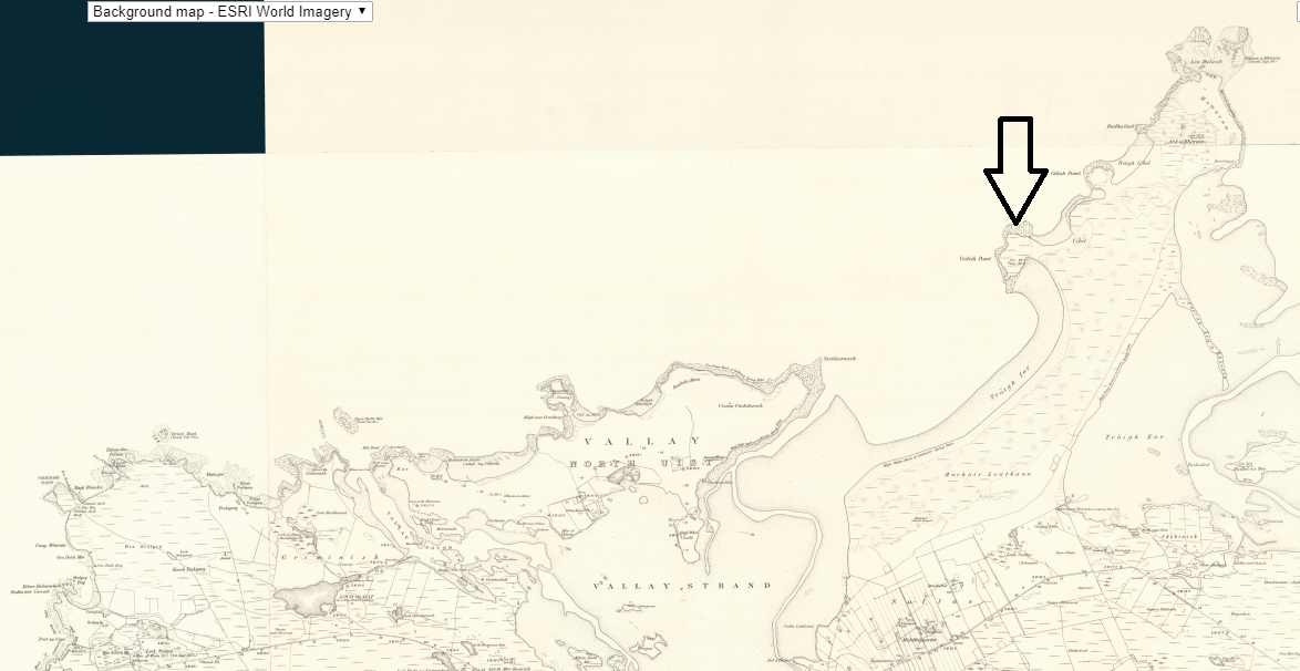
The map extract illustrates the NW corner of North Uist, the NW corner of the whole Western Isles chain. Whales being driven from the NW could follow the coast east, past the island of Vallay and would then end up trapped under the Veilish Point and beach themselves here.
Finds at the adjacent Udal excavation on the peninsula included whale-bone as evidence of their use.
The third veil place in Reay is outwith the scope of this document.
Other possibilities
Further consideration of the Gaelic dealings with the Norse language and considering places near to the ones discussed reveal another possible veil root.
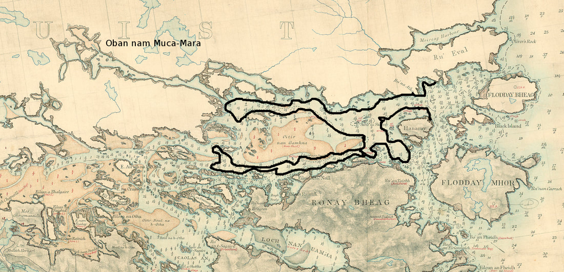
A’Mheallairt is the name for the headland opposite the SW tip of Liernis, just south of Oban nan Muca-mara. The Gaelic meaning would be “High Lump” as recorded in the OS name book. The A’ article in front is a little odd and often indicates an older name and also perhaps an uncertainty about the meaning of the Mheallairt component of the name.
Gaelic pronunciation for Mheallairt would be anglicized to v é ll I rsht. As can be seen the mheall section could be taken as another veil sounding name. One possible interpretation here then is another ON hvalr + hus = house of the whale.
Scottish Gaelic Meall is a common topographical generic component and generally refers to a lumpy hill. It was only proximity and the curious article that alerted one to the possibility of an alternative meaning for Mheall in this case.
Mhail is another variant which occurs ten times in Great Britain, six times on the Western Isles. Unfortunately mhàil also means rent in Gaelic and whilst three of these sites are at loch heads, they could well be referring to rent-collection rather than driven whales!
The three names on the Western Isles without the accented mhail are Geo Mhail (on the NW coast of North Uist and close to Hosta’s Manish), Barra-mhail (a muddy bay at the end of Loch Euphort) and Eilean a’ Mhail. There is one more in Scotland, Druim a’ Mhaill on the shores of Loch a’ Chumainn on the NW corner of Mull. All of these seem unlikely to be to do with rent collection.
The first, Geo Mhail is a small rocky inlet where one can envisage the occasional dead whale being washed up but not otherwise.
Druim ‘a Mhaill on Mull is on the shores of a long narrow sea loch that fits the topographic requirements for whale driving. Interestingly in the loch below Druim a’ Mhail is ScG Sgeir na Comh-stri = Skerry of strife and exactly the same name appears in both Loch Euphort near Barra-mhail, North Uist and near Eilean nam Muca-mara, Carinis North Uist.
Eilean a’ Mhail is near Meall nam Buth (Lumpy hill of the shop) and so could be a mistranscription of that meall although is not far from the narrow sea inlet leading to Loch Obe and Balnabodach.
Barra-mhail is the most interesting topographically as it lies at the end of the ten kilometre Loch Euphort, a sea loch with a narrow entrance to the E in the Minch and one that steadily gets narrower and shallower as it progresses to the W. Barra-mhaill is the final muddy shore at its E extremity.
Finds at the adjacent Udal excavation on the peninsula included whale-bone as evidence of their use.
The third veil place in Reay is outwith the scope of this document.
Other possibilities
Further consideration of the Gaelic dealings with the Norse language and considering places near to the ones discussed reveal another possible veil root.
A’Mheallairt is the name for the headland opposite the SW tip of Liernis, just south of Oban nan Muca-mara. The Gaelic meaning would be “High Lump” as recorded in the OS name book. The A’ article in front is a little odd and often indicates an older name and also perhaps an uncertainty about the meaning of the Mheallairt component of the name.
Gaelic pronunciation for Mheallairt would be anglicized to v é ll I rsht. As can be seen the mheall section could be taken as another veil sounding name. One possible interpretation here then is another ON hvalr + hus = house of the whale.
Scottish Gaelic Meall is a common topographical generic component and generally refers to a lumpy hill. It was only proximity and the curious article that alerted one to the possibility of an alternative meaning for Mheall in this case.
Mhail is another variant which occurs ten times in Great Britain, six times on the Western Isles. Unfortunately mhàil also means rent in Gaelic and whilst three of these sites are at loch heads, they could well be referring to rent-collection rather than driven whales!
The three names on the Western Isles without the accented mhail are Geo Mhail (on the NW coast of North Uist and close to Hosta’s Manish), Barra-mhail (a muddy bay at the end of Loch Euphort) and Eilean a’ Mhail. There is one more in Scotland, Druim a’ Mhaill on the shores of Loch a’ Chumainn on the NW corner of Mull. All of these seem unlikely to be to do with rent collection.
The first, Geo Mhail is a small rocky inlet where one can envisage the occasional dead whale being washed up but not otherwise.
Druim ‘a Mhaill on Mull is on the shores of a long narrow sea loch that fits the topographic requirements for whale driving. Interestingly in the loch below Druim a’ Mhail is ScG Sgeir na Comh-stri = Skerry of strife and exactly the same name appears in both Loch Euphort near Barra-mhail, North Uist and near Eilean nam Muca-mara, Carinis North Uist.
Eilean a’ Mhail is near Meall nam Buth (Lumpy hill of the shop) and so could be a mistranscription of that meall although is not far from the narrow sea inlet leading to Loch Obe and Balnabodach.
Barra-mhail is the most interesting topographically as it lies at the end of the ten kilometre Loch Euphort, a sea loch with a narrow entrance to the E in the Minch and one that steadily gets narrower and shallower as it progresses to the W. Barra-mhaill is the final muddy shore at its E extremity.
 RSS Feed
